Aerial Views Document Texas Destruction
Severe storms once again impacted the Plains on Sunday, marking a continuation of a multi-day period of dangerous weather. This report compiles our live updates from Sunday evening. For an outlook on the severe weather and tornado risks in the coming days, consult our detailed forecast.
(08:52 p.m. EDT) Overnight Weather Outlook
Forecasters Rob Shackelford and Caitlin Kaiser provide this update:
The potential for severe storms is anticipated to persist throughout the night, particularly across the Central Plains.
Strong tornadoes could develop in southern Kansas and northern Oklahoma within the next hour or so.
The system responsible for the significant tornado in Sycamore, Kansas, is moving eastward through southern Kansas, with Missouri in its path. Although no tornado is currently observed, storms with a history of producing tornadoes are capable of renewed activity.
As of this evening, the Plains have experienced 41 hail incidents, 16 damaging wind events, and two confirmed tornadoes. These figures are expected to increase overnight.
(08:41 p.m. EDT) Sycamore, Kansas, Reports Damage
Emergency services have reported damage in Sycamore, Kansas—a town of approximately 70 residents in Montgomery County—though the extent is still unknown. Fire and EMS units are en route to the location.
(08:26 p.m. EDT) Sycamore, Kansas, Under Tornado Threat
Charles Peek, a storm chaser, has posted social media video depicting a tornado forming in Sycamore, Kansas, a community currently under a PDS (Particularly Dangerous Situation) tornado warning:
(08:13 p.m. EDT) Southeastern Kansas Under PDS Tornado Warning
Montgomery County, located in southeastern Kansas, is now under a “particularly dangerous situation” (PDS) tornado warning. This warning encompasses communities such as Sycamore and Cherryvale.
The National Weather Service has issued a grave alert: “You are in a life-threatening situation. Flying debris could be lethal for anyone without adequate shelter. Mobile homes face destruction. Significant damage to residences, businesses, and vehicles is probable, with total annihilation possible.”
Given the ongoing tornado threat for the next few hours, it’s important to understand the different classifications of tornado warnings.
The initial type is a “radar-indicated” tornado warning. This signifies that while a tornado hasn’t been visually confirmed, one is imminent. These warnings demand the same level of seriousness as any other.
Next are tornado warnings designated as “confirmed,” which can be either radar-confirmed or spotter-confirmed.
Following these are Particularly Dangerous Situation (PDS) Confirmed Tornadoes. These uncommon warnings represent an elevated threat level, indicating an exceptionally high risk of severe damage and fatalities.
The highest classification is a tornado emergency, the rarest warning, reserved for critical and life-threatening scenarios.
Further details on these warning types can be found by clicking here.
(07:56 p.m. EDT) New Tornado Watch for Missouri
Meteorologist Rob Shackelford reports:
Southern Missouri is now under a tornado watch, effective until 2 a.m. local time.
Key hazards include the potential for several tornadoes, hail up to tennis ball size (2 inches in diameter), and wind gusts reaching 70 mph.
Across the four active tornado watches, the total population affected now exceeds 4 million individuals.
(07:33 p.m. EDT) Record Hail Size Reported
Caitlin Kaiser, Meteorologist, notes:
Iowa City, Texas, recorded a 3-inch diameter hailstone, marking the largest hail reported this evening.
The likelihood of 2- to 3-inch hail, along with tornado potential, is rising across northern Texas and southern Oklahoma.
Madison, Kansas, also saw a significant 2-inch hailstone. Overall, over 20 hail reports have been received tonight, predominantly from Kansas, and this figure is projected to climb throughout the night.
(07:14 p.m. EDT) Forecast for the Remainder of the Evening
According to Meteorologist Rob Shackelford:
With storm activity intensifying across the Central Plains, here’s a short-term forecast outlining expected storm locations over the next several hours.
The primary storm front under observation is advancing from southern Kansas into Iowa and Missouri. This system, fueled by ample moisture and instability—key elements for severe storm formation—has previously triggered severe thunderstorm and tornado warnings. The most intense storms are anticipated at the southern extremity of this initial line.
Additional storms are expected to develop behind this initial front, passing through the same regions in the hours ahead. This could lead to a subsequent wave of strong winds, large hail, and even the potential for a powerful tornado. As this second round mirrors the path of the first, heavy rainfall is also a significant concern, alongside the severe storm risks.
(06:50 p.m. EDT) Damage Near Kansas City From Storms
Local storm reports indicate that homes were damaged and a barn was demolished near Edgerton, Kansas, southwest of Kansas City. Additional information was not immediately accessible.
(06:32 p.m. EDT) Oklahoma, Arkansas Under New Tornado Watch
Meteorologist Rob Shackelford states:
Tornado watches are becoming more widespread across the Central Plains as regional storm activity intensifies.
The third tornado watch for the evening has been declared for portions of northeastern Oklahoma and northwestern Arkansas, encompassing Tulsa, Oklahoma.
The primary dangers include the possibility of several strong tornadoes, large apple-sized hail (3 inches in diameter), and wind gusts up to 70 mph.
The cumulative population residing within the three active tornado watches now exceeds 3.5 million.
(06:16 p.m. EDT) Severe Storms Brewing in Texas
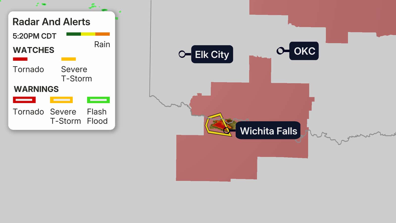
Meteorologist Caitlin Kaiser reports:
Following a calm afternoon, storm activity is now emerging in Texas.
The initial severe thunderstorm warning for Texas has been issued for a storm cell advancing towards Wichita Falls.
This storm carries the potential for golf ball-sized hail and wind speeds reaching 60 mph.
Conditions are projected to worsen in the tornado watch area over the next few hours.
(05:55 p.m. EDT) Essential Severe Weather Safety Tips
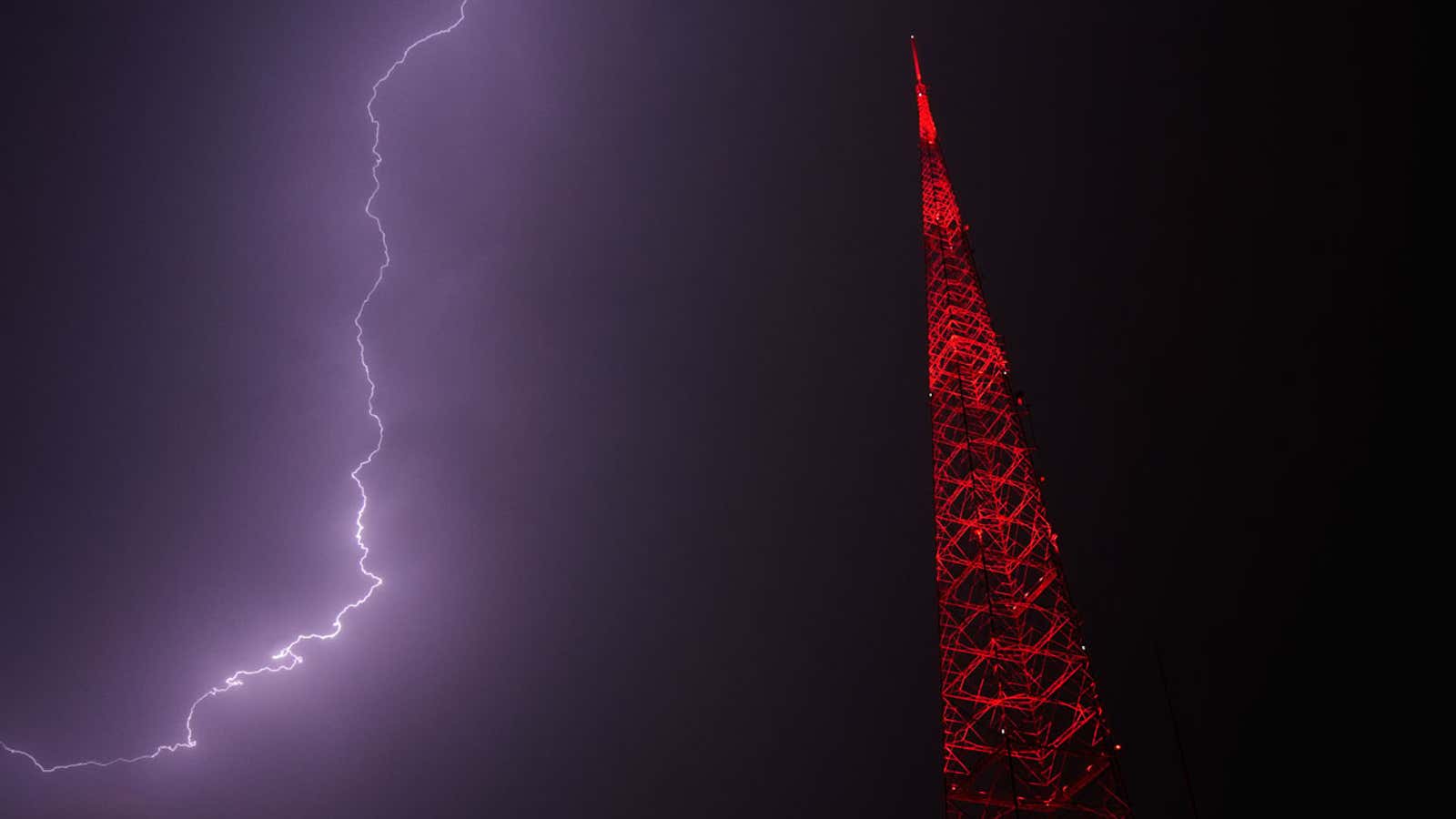
Lightning illuminates the sky behind a television tower during a thunderstorm on Thursday, April 23, 2026, in Kansas City, Missouri.
(Photography by Charlie Riedel/AP)
Is your region anticipating severe weather tonight? Preparation is crucial before storms arrive.
Meteorologist Caitlin Kaiser outlines common errors and provides vital, potentially life-saving preparation advice here.
(05:40 p.m. EDT) Intense Storms Persist in Eastern Kansas, Western Missouri
Meteorologist Rob Shackelford provides an update:
An active storm line is currently tracking across eastern Kansas, situated just south of Kansas City.
These storms are under severe thunderstorm and tornado warnings, with potential for 70 mph gusts, ping-pong-ball-sized hail, and even a tornado.
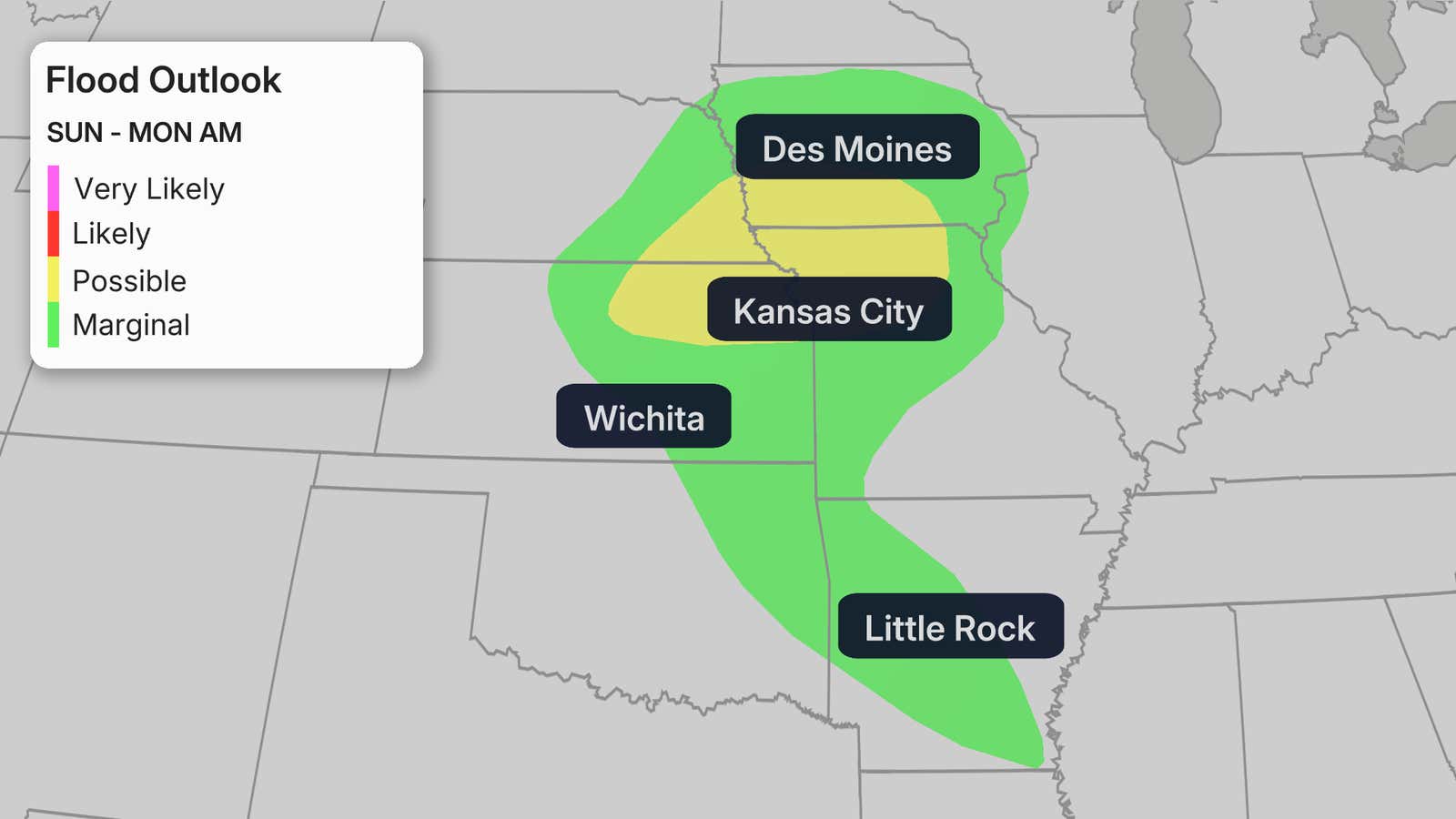
Further storms are anticipated to develop in the wake of this line, causing heavy rainfall to “train” over the same regions. This could result in flash flooding, with rainfall rates of 1 to 2 inches per hour possible. A flood watch is currently active for these areas, including Kansas City.
(04:56 p.m. EDT) New Tornado Watch Implemented
Digital Meteorologist Caitlin Kaiser reports:
A tornado watch is now in effect for portions of Oklahoma and Texas until 11 p.m. local time. Primary concerns include apple-sized hail, wind gusts reaching 70 mph, and the chance of a few tornadoes.
(04:23 p.m. EDT) Missouri, Kansas Under Tornado Watch
Digital Meteorologist Rob Shackelford states:
The initial tornado watch for the evening has been issued for areas of Kansas and Missouri, valid until 11 p.m. local time.
Key threats include tornadoes, hail as large as tennis balls, and wind gusts potentially reaching 75 mph.
Learn to distinguish between a tornado watch and a tornado warning here.
(04:12 p.m. EDT) Overnight Tornadoes Pose Greater Danger
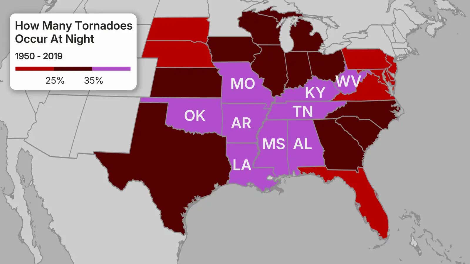
Tornado risks are forecast to extend into the night, with recent research indicating that nocturnal tornadoes are almost twice as lethal as those occurring during the day.
This heightened danger stems from multiple factors, primarily visibility. Overnight tornadoes are only briefly visible by lightning flashes.
Furthermore, fewer storm chasers and trained spotters are active after nightfall.
The most significant contributor to increased fatalities from nighttime tornadoes is the risk of being asleep as a storm passes through your location.
Meteorologist Rob Shackelford provides a full explanation here.
(03:56 p.m. EDT) Projected Hail Sizes for Tonight
Caitlin Kaiser, Meteorologist, reports:
Tonight’s severe weather may produce large to very large hail across portions of the Plains, impacting cities such as Kansas City, Wichita, Dallas, and Oklahoma City.
Hailstones could reach 2 to 3 inches in diameter. What does this size represent?
A 2-inch hailstone is roughly the size of a hen’s egg, whereas 3-inch hail compares to a large apple.
Additional information on hail and its potential impact on people and property is available here.
(03:26 p.m. EDT) Further Information on Fatal Texas Tornadoes
The Associated Press reports that two individuals perished late Saturday evening due to tornadoes that inflicted extensive home damage across several North Texas communities. An EF2 tornado, with 130-mph winds, resulted in one fatality in Runaway Bay. Later that night, an EF1 tornado, packing 105-mph winds, claimed another life on the south side of Springtown.
Wise County Judge J.D. Clark informed reporters, “Access has been challenging because of road blockages and fallen utilities, yet teams have persistently worked to reach affected residents.” He added, “Law enforcement will keep roads in the impacted zone closed to maintain safety and facilitate unobstructed work for emergency personnel.”
(03:08 p.m. EDT) Afternoon Update: Current Situation
Meteorologist Jennifer Gray provides an overview:
A hazardous weather pattern, already responsible for two fatalities, is persisting across the Plains and Midwest, extending into the beginning of the week. Substantial risks of tornadoes, hail, and damaging winds are anticipated through Tuesday.
Supercell thunderstorms pose a threat across the Central and Southern Plains, particularly in regions of Kansas, Nebraska, and Missouri.
Given the presence of warm, humid air and significant wind shear, these supercells are capable of generating powerful tornadoes, alongside very large hail and destructive wind gusts. Residents in cities such as Kansas City and Oklahoma City should remain vigilant.
A somewhat reduced, but still significant, severe storm threat involving large hail and damaging winds may affect urban areas including Dallas, San Antonio, and Austin.