Wintry precipitation will persist across southern New Hampshire until Friday morning
A live look at Manchester roads via Storm Tracker shows sleet is already making conditions messy. Chief Meteorologist Mike Haddad notes the current weather is a “smorgasbord of excitement” if you’re not driving, with sleet creating slush that will make roads slippery through Friday morning’s commute, including in Manchester. He explained that sleet forms when rain in warmer cloud layers freezes before hitting the ground, creating ice pellets. This differs from freezing rain, which freezes upon impact and is a common cause of power outages, though widespread outages are not expected tonight. Currently, freezing conditions are prevalent across many areas, including the Merrimack Valley up to Laconia, the Upper Valley, and south to the coastline, where precipitation is actively falling. This means impacted travel with periods of snow and some icing, especially in central and southern regions, extending into tomorrow’s commute. Doppler radar indicates frozen precipitation (blue and purple) which is hazardous for travel, with sleet mixing with wet snow. Over the next few hours, heavier precipitation from New York (indicated by orange and red bands) is expected to cool the atmosphere, transforming precipitation into all wet snow. Consequently, 3 to 4 inches of wet snow are anticipated in central and southern parts of the state. This system, which has already moved through Buffalo, should exit the area by 8 or 9 AM Friday. Northern areas, including the Great North Woods, Mount Washington Valley, and Franconia Notch, will see minimal impact, perhaps just a flurry. After the system departs by 9 AM, clouds will linger through Friday afternoon with light onshore winds and a chance of drizzle or freezing drizzle. However, widespread road issues are unlikely as temperatures will be near 32 degrees, and the strong March sun angle should help clear roads even through cloud cover. Saturday morning will bring a warm front with scattered showers, primarily in central and northern areas. By Saturday afternoon, clouds will break, and temperatures will climb to between 45 and 50 degrees. Regarding snowfall and sleet accumulation overnight, expect 2 to 3 inches of snow combined with 0.5 to 1 inch of sleet in many locations. If conditions favor more wet snow, totals could be higher; more sleet might result in lower snow accumulation. Farther north, 1 to 3 inches are possible, with a coating to an inch up to Conway and areas south. Looking ahead, temperatures will be cold tonight and Friday, remaining in the 30s. However, a significant warming trend begins this weekend, with 45 to 50 degrees on Saturday and 50 degrees or higher on Sunday. Don’t forget, it’s a “spring ahead” weekend, so we lose an hour, but sunset will be at 6:44 PM. Monday could see upper 50s, possibly near 60, with an even better chance of 60 degrees on Tuesday. Predicting temperatures 6 or 7 days out for next Wednesday is challenging. Nevertheless, spring is definitely approaching, both meteorologically and in general. “I’m ready to turn the corner on winter and have warmer weather for a month or two.”
The wintry mix is expected to continue across southern New Hampshire through Friday morning

Updated: 5:02 AM EST Mar 6, 2026
Editorial Standards
A combination of snow and sleet is forecast to continue through early Friday across much of southern and central New Hampshire, creating hazardous travel conditions. The winter storm began Thursday evening in the Granite State, initially as rain before transitioning to freezing rain, which resulted in slushy roads. The most significant impacts are expected in central and southern New Hampshire, while areas north of the Mount Washington Valley, extending to the Great North Woods, may only receive a light accumulation. >> See the latest hour-by-hour timeline: Most areas south of the White Mountains can expect 1 to 3 inches of snow, with some southern locations, particularly south of the Lakes Region, potentially receiving 3 to 6 inches. ROADS WILL REMAIN SLICK FRIDAY MORNING Roads will remain dangerous on Friday morning, with slick spots likely impacting the commute. The heaviest precipitation is anticipated until 7 to 8 a.m., followed by the possibility of isolated light drizzle or freezing drizzle later in the morning as clouds persist. Temperatures will stay low on Friday, with highs in the 30s, before a weekend warm-up. Stay weather aware! Download the WMUR app and enable push notifications. You can opt to receive weather alerts based on your current location and/or up to three ZIP codes. Additionally, you can get alerts for incoming precipitation in your vicinity. Access storm coverage on your smart TV via the free Very Local app. Follow the Storm Watch 9 team on social media: Mike Haddad: Facebook | X Kevin Skarupa: Facebook | X Hayley LaPoint: Facebook | X Jacqueline Thomas: Facebook | X Matt Hoenig: Facebook | X
A mix of snow and sleet is expected to persist across central and southern New Hampshire into early Friday, leading to challenging travel conditions.
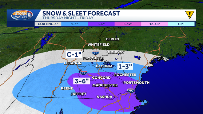
The winter weather system entered the Granite State Thursday evening, initially as rain before transitioning to freezing rain, which created slushy road surfaces.
The central and southern regions of New Hampshire are predicted to experience the most significant impacts, while areas north of Mount Washington Valley, including the Great North Woods, may only receive a light accumulation.
>> See the latest hour-by-hour timeline:
A widespread forecast of 1 to 3 inches of snow is expected for most areas south of the White Mountains, with certain southern locations, particularly south of the Lakes Region, potentially receiving 3 to 6 inches.
WINTER WEATHER CONTINUES FRIDAY MORNING
Roads will remain hazardous throughout Friday morning, with slick patches likely affecting the commute.
The most consistent precipitation is anticipated until 7 to 8 a.m., with isolated light drizzle or freezing drizzle possible later in the morning as cloud cover lingers.
Friday’s temperatures will remain low, with highs in the 30s, before a noticeable warming trend over the weekend.
Stay informed about weather conditions! Download the WMUR app and enable push notifications. You can opt to receive personalized weather alerts for your geolocation and/or up to three ZIP codes, as well as notifications for incoming precipitation in your vicinity.
Access comprehensive storm coverage through the free Very Local app on your smart TV.
Connect with the Storm Watch 9 team on social media: